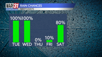


Rain is back Tuesday followed by the coldest air of the season so far later in the week.
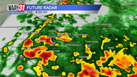
Clouds will increase overnight with some rain coming in after midnight. We'll be breezy with overnight lows in the mid 60s.
Keep the umbrellas handy on Tuesday. We'll see rain at times with a few embedded storms. Another breezy and mild day is ahead with high temperatures close to 70. The chance of rain is around 70%.
Temperatures will start to fall on Wednesday although we'll still reach the low 60s for highs. We'll be windy and dry otherwise with a mix of clouds and sunshine.
Cooler weather settles in for the end of the week. Highs Thursday and Friday will only be in the low to mid 50s with morning temperatures in the upper 30s. More windy and partly cloudy, but dry conditions are ahead.
Temperatures will start to recover this weekend. Mornings will stay cold in the mid 30s, but the afternoons will get milder. After staying in the mid 50s Saturday, we'll warm back into the mid 60s Sunday.
Next week starts mild with highs around 70, but another weather maker brings rain back and another cool down as we near Thanksgiving.
TONIGHT: Clouds and rain moving in. Lows in the mid-60s. Wind: SE 10-15, gusts 25 mph.Â
TUESDAY: Rain likely with a few storms. Highs close to 70. Wind: S 6-12 mph.