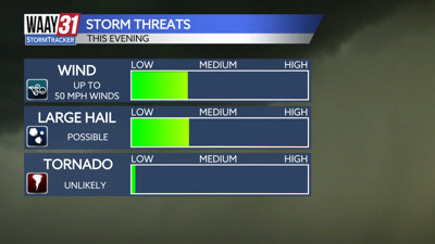


***SEVERE THUNDERSTORM WATCH UNTIL 11PM***
Scattered showers and a few thunderstorms will become more likely as we head into the evening hours tonight. Some of the storms could be on the stronger side with gusty winds and large hail. Timing for the severe threat looks to be from 6pm - 10pm this evening. Things will calm down as we head into the overnight hours tonight. Lows for tonight will fall back into the upper 40s.
Friday will be cooler with clouds hanging around for a good part of the day which will make it hard for temperatures to warm past the upper 50s. A few scattered showers will also be possible in the afternoon hours.
This weekend stays sunny and calm. Saturday's high temperature only reaching to the low 60s and Sunday we will warm to the mid-70s.
Next week is another mixed bag with highs on Monday in the 80s but the rest of the week will feature a few rain chances and highs in the 70s.
TONIGHT: Rain will come to an end. Lows in the upper 40s. Wind: NW 5-10 mph.
FRIDAY: Cooler. A few isolated showers Highs around 60. Wind: NW 10-15 mph, gusts 20 mph.