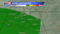

More rain on the way this afternoon.. Some of the storms could be on the stronger side with gusty winds and large hail being the main threats. The tornado threat is very low. High temperatures will warm to the lower to middle 70s.
Tomorrow and Thursday are finally trending drier! High temperatures will warm to the low and mid-80s both days. Wednesday will feature some early afternoon rain but that will be the last of it for a day or two.
Rain chances return starting Friday. Showers and few storms will be possible in the afternoon hours. The storm prediction center has a slight risk of severe weather just off to our north and west so worth watching. Greatest threat from any stronger storms will once again be gusty winds and some large hail.
The weekend will feature yet again more rain. Neither day looks like a total washout but another weekend that will need some backup indoor plans. Highs will be in the upper 70s to lower 80s both days.
TODAY: More scattered storms. Highs in the mid-70s. Wind: SW 5-10 mph.
TONIGHT: Rain ends, cloudy. Lows in the low 60s. Wind: Light SE.