

A warm stretch of weather ahead that will carry us into February may give you spring fever. The first 70 degree weather of the year could arrive by the end of the weekend. We do have one weather maker we'll have to get through before then with rain expected as we close out the week.
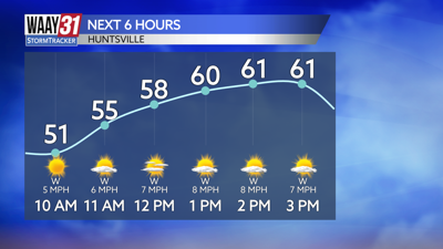
Cloud cover will start to move in as we head into the afternoon hours today. Temperatures will be the warmest of the year so far, topping out in the lower to middle 60s.
Clouds increase Thursday and a few showers may pass through. Rain is expected to be widespread Thursday night into Friday morning before tapering off early Friday afternoon. No severe weather is expected but winds will be breezy as the system moves through. Temperatures will stay in the low to mid 60s as we close out the week.
Right now the weekend looks pleasant and dry. Highs will be in the low 60s Saturday, but we'll be very close to 70 on Sunday.
The mild conditions continue into next week with rain chances returning again later in the week.
TODAY: Partly cloudy and mild. Highs in the mid 60s. Wind: NW 5-10 mph.
TONIGHT: Cloudy. Lows in the lower 40s. Wind: Light SE.